
Streets beginning with
A B C D E F G H I J K L M N O P Q R S T U V W X Y Z

You are here: Home > Places > Streets > Streets F
Streets beginning with A B C D E F G H I J K L M N O P Q R S T U V W X Y Z | Search the site |
| F | Census districts lists Click on any image to open it in a new window |
references | |
| ∫ Fairfield Crescent, Hollingbury | Withdean Estate East. Former name of Hartfield Avenue. Named 5 April 19381. | 1ESRO DB/D/27/41 | |
| Fairfield Gardens, Portslade BN41 2 |
Mostly two-storey semi-detached hosuing. | Ke1947— | |
| Fairlie Gardens, Surrenden BN1 6 |
Cul-de-sac of bungalows off Surrenden Crescent. Numbered 15 March 19711. | Ke1973— 1ESRO DB/D/27/436 |
|
| Fairlight Place BN2 3 |
Fairlight is an East Sussex village east of Hastings. Seven three-storey terraced houses on west side. †Fairlight Place Schools, designed by Thomas Simpson, opened in 1876 and enlarged in 1883 and 1901. Also known as Lewes Road Schools. It was reorganised in 1928 into infants, junior mixed and girls departments but demolished and rebuilt in 1932 (see St Leonard's Road). |
Pa1872 | |
| Fairview Rise, Withdean BN1 5 |
Short and steep of two-storey semi-detached housing.Numbered 29 October 19591. | Ke1956— 1ESRO DB/D/27/363 |
|
| Fairway Crescent, Portslade BN41 2 |
Two-storey terraced housing, | Ke1964— | |
| Fallowfield Close, West Blatchington BN3 7 |
Abergavenny land. Two-storey semi-detached housing off Fallowfield Crescent. | Ke1947— | |
| Fallowfield Crescent, West Blatchington BN3 7 |
Abergavenny land. Semi-detached bungalows. 7 (Dee Sea) and 9 built c1937 by Braybons for Winchester Estates Development Company (Brighton) Ltd1. |
Ke1947— 1ESRO ACC8745/61 |
|
| FALMER | 'Pleasant pool' (OE fæle mere). Identified in Domesday Book as Falemere, a Saxon name, the ancient parish to the north-east of Brighton comprises the manors of Bevendean, Falmer and Patchway. Parts of Falmer were incorporated into the County Borough of Brighton in 1928 under the Brighton Corporation Act 1927, the rest being absorbed in 1952. The area is now dominated by the campus of the University of Sussex. Falmer Pond is the origin of the village's name. In Victorian times it was a favoured place for skating when it froze over. 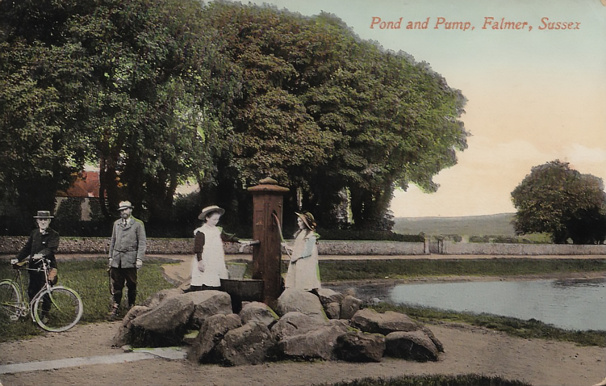 Falmer pond and pump (1919). |
||
| Falmer Avenue, Saltdean BN2 8 |
Numbered 4 June 19641. | Ke1949— 1ESRO DB/D/27/411 |
|
| ∫ Falmer Close, Woodingdean | Former name of Falmer Gardens. Numbered 6 October 1955, supplementary numbering 4 June 19591. Extension named 24 January 19662. | Ke1966— 1ESRO DB/D/27/327 2ESRO DB/D/27/352 |
|
| Falmer Gardens, Woodingdean BN2 6 |
Formerly known as Falmer Close. | Ke1969— | |
| Falmer House Road, Falmer | University of Sussex campus access road. | ||
| Falmer Road, Rottingdean, Ovingdean, Woodingdean, Falmer (B2123) BN2 6, BN2 7 CA: Rottingdean (Downlands, 1-4 Northgate Cottages, 1-4 Challoners Cottages, Flint Wall to The Rotyngs). |
The longest continuous road in the city, four miles overall, from Rottingdea to Famer, via Ovingdean and Woodingdean. At Woodingdean it was formerly known as Downs Road, which was numbered 16 June 19485. The more southerly section was part numbered 19 April 1955 and from The Green to Court Farm Road 21 April 19711. WEST SIDE south to north —Continues from The Green. —Here is Challoners Mews. Bowling Green Old Cart Lodge and Barn are on the B&H local list. 1-4 Northgate Cottages date from the 18th century, except for no 4, which bears the inscribed date 1881 with the initials S&GHB. Grade II listed4. —Here is Burnes Vale. —Here is The Rotyngs. —Here is a path that leads to The Green. —Here is Wilkinson Close (at 35). —Here is Meadow Close. —Here is Court Ord Road. —Here is Beacon Close. —Here are Court Farm Road and New Barn Road. —Here is New Barn Road. —Here is The Vale. Longhill High School officially opened in 1964. —Here is Ovingdean Road. —Here is Crescent Drive South. —Here is Warren Road. —Here is McWilliam Road. —Here is Drove Road. —North of here it is known as The Drove. —Here is Village Way. EAST SIDE south to north Challoners [qv] dates internally from the 15th and 16th centuries with a frontage from the 18th century. Grade II listed2. Little Challoners was built in 1804 and is Grade II listed2. —Here is Bazhill Road. New Barn dates from the 18th and 19th centuries and is Grade II listed3. Rottingdean Place was built in 1912 as St Mary's Home for Female Penitents, which had previously been in Queen Square. The home closed in 1974. The property was bought by the Church of Scientology in 1980 but sold on for residential development. Sisters of the Community of the Blessed Virgin, a religious order founded by Rev Arthur Wagner, retain the right to burial in the graveyard associated with the former chapel. —Here is Cowley Drive. —Here is Brownleaf Road. (at 380) —Here is Crescent Drive South. (at 400) —Here is Millyard Crescent (at 414). —Here is Briarcroft Road. (at 466) 478 was built in 1933 by H Tuppen for A Pitt6.. —Here is Falmer Gardens. (at 524) —Here is Warren Way. (at 548) —Here is Bexhill Road. †Wick Farm. —Here is Drove Avenue. —Here is Park Street. 1  2 2 1. Falmer Road northern end at Warren Road; 2. Rottingdean Prep School, Falmer Road. |
Ke1947— 1ESRO DB/D/27/285 2HE 1380500 3HE 1380501 4HE 1380502 5 image 6ESRO DB/D/7/9378 (27 Jul 1933) |
|
| Farm Close, Portslade BN41 2 |
Originally at North House Farm. | Ke1964— | |
| Farm Hill, Woodingdean BN2 6 |
Part of the Wick Estate. Numbered 29 April 19481. | 1ESRO DB/D/27/283 | |
| Farm Mews, Hove CA: Brunswick Town. |
Accessed through an archway at 12 Farm Road. | ||
| Farm Road, Hove BN3 1 CA: Brunswick Town. |
The street led to Wick Farm. One cottage 'and ten other houses unfinished' listed in Fo1852. Several mews are to the rear of the west side at 12 (Farm), 16 (Goldsmid), 18, 19-20 and 22. ph 3, Lansdowne Arms opened in 1856, associated with livery stables in Lansdowne Mews. The name was changed to Coopers Cask early this century. PArt of the Stonegate chain it was closed in 2025. —Here is Lansdowne Mews. —Here is Farm Mews. ph 13, Farm Tavern opened in 1856 and has kept its name ever since. |
Fo1852— | |
| Farm Yard | Now a small enclosed cul-de-sac off the north-east corner of Churchill Square but until the end of 18th century a large farm yard to the east of Upper Russell Street. | [1826] | |
| Farman Street, Hove BN3 1 CA: Brunswick Town. |
Originally at 7 Western Road, now a cul-de-sac from Cross Street. It is subject to a Public Space Protection Order. Hove National School. 1855. |
Br1845— | |
| Farmway Close, Hangleton BN3 7 |
Partly follows the line of the lane to the former Hangleton Farm. | Ke1964— | |
| Fenchurch Walk BN1 4 |
Stepped pedestrian area, formerly Ann Street, renamed west of New England Street, with access to the railway station (Stroudley Road) at the western end. | ||
| Ferndale Road, Hove BN3 6 |
The road was one of a group laid out in 19061. Two-storey late Edwardian terraced housing. | Pi1912— 1ESRO DO/C/6/2899 (13 Dec 1906) |
|
| Fernhurst Close, Patcham BN1 8 |
Northward continuation of Ferndale Crescent. Cul-de-sa with turning circle. | Ke1956— | |
| Fernhurst Crescent | Semi-detached two-storey housing | Ke1954— | |
| Fernwood Rise, Westdene BN1 5 |
Numbered 4 July 19531, supplementary numbering 7 February 19572. | Ke1856— 1ESRO DB/D/27/311 2ESRO DB/D/27/343 |
|
| Findon Close, Hangleton BN3 8 |
One of a group of adjoining roads named after Sussex villages. | Ke1951— | |
| Findon Road, Whitehawk BN2 5 |
One of a group of adjoining roads named after Sussex villages. Social housing replaced post-WW2 prefabricated housing1. Supplementary numbering 3 September 1964, 1 November 19662, part numbering 3 August 19833. | Ke1933— 1Aerial photo 1947. 2ESRO DB/D/27/414 3ESRO DB/D/27/445 |
|
| Finsbury Road BN2 6 |
Crown Hill. Council flats on the corner with Southover Street. Hanover Lofts was built as Finsbury Road Board School, which was later a county primary school and then the fashion and textiles department of Brighton Polytechnic (later the University of Brighton) before conversion to apartments. It was designed by Thomas Simpson, the Brighton & Preston School Board architect, and opened in 1881. †Brighton Home for Female Penitents (Albion Hill Home), a Magdalen home, was founded in 1853 in Lewes Road by Rev George Wagner and Mrs Murray Vicars to rescue women from prostitution. It moved to Queen Square in 1855 and to new-build premises at this site in 1868. It was taken over by the Church Army in 1917 and closed after World War II, becoming a furniture factory by 1954. It was demolished and replaced by in 1972. Westmount, an extensive block of council flats. |
Pa1871— | |
| Fir Close, Woodingdean BN2 6 |
Cul-de-sac of three detached houses off Foxdown Road. | ||
| Fircroft Close, Withdean BN1 6 |
Takes its name from Fir Croft (1881), the Victorian house, built around 1860, that stood on the site (see Varndean Drive). | ||
| Firle Road BN2 9 |
Inter-war years pebbledash council housing development named after local Sussex villages (cf, Glynde Road). | Pi1925— | |
| First Avenue, Hove BN3 2 CA: The Avenues. |
One of four sequentially numbered avenues running off Kingsway parallel with and on either side of Grand Avenue. The land was part of more than 40 acres let by the Stanford Estate in 18714. Four properties were listed 'and other houses unoccupied' in Pa1875. 2 was the constituency residence of Bruce Cannin Vernon-Wentworth, MP for Brighton. It then became, with 4 and 6a, the Imperial Ladies' Club. Pillar box outside 11 bears the VR royal cipher. 12 was the childhood residence of novelist Patrick Hamilton (1904-1962). Plaque sponsored by Penguin Books. 36 was the residence of Chief Rabbi Dr Nathan Marcus Adler from 1880 until his death1, although the property was listed as unoccupied in the 1891 census. 41 is Grade II listed2. 56 is Grade II listed3. |
Pa1875— 1Jtrails 2HE 1309640 3HE 1280737 4The Builder, 27 May 1871:409 |
|
| † Fish Market | This was on the beach due south of East Street. Boats could be hauled up onto the beach for unloading. It was closed as unhygienic in 1960 and moved to a purpose-built site in Circus Street. 1  2 2 3 3 Brighton Fish Market [Source 1: Brighton & Hove Museums]. |
||
| ∫ Fishbourne Road or Street, Hove | This was the name given to Eaton Gardens in the original plans for the Cliftonville area1. Fishbourne is a village and site of a Roman palace near Chichester. | 1ESRO DO/C/6/181 | |
| Fitch Drive, Bevendean BN2 4 |
No through road of terraced housing and council flats. A footpath leads from the west end to Willingdon Road. Alderman Stan Fitch lived in Lower Bevendean. | ||
| Fitzherbert Drive, Bevendean BN2 4 |
Built 2005 (?) on the site of the former Bevendean Hospital, belatedly commemorates Mrs Maria Fitzherbert. | ||
| FIVEWAYS | Area around conjunction of three roads—Hollingbury Road, Preston Drove, Stanford Avenue—with Ditchling Road. | ||
| ∫ Fleet Street | Former name of the section of New England Street south of Ann Street to Cheapside. But see next entry. 1  2 2 1. Fleet Street; 2. Looking south. |
Ta1854— | |
| Fleet Street BN1 4 |
The name was revived for a new road in New England Quarterbetween Cheapside and New England Street. | ||
| Fletching Close, Whitehawk BN2 5 |
Winding cul-de-sac off Whitehawk Way. It retained the name of the former Fletching Road. Fletching is a Wealden village. Thw road was numbered 3 August 19831. | 1ESRO DB/D/27/445 | |
| † Fletching Road, Whitehawk | One of the longer roads lost in the remodelling of the Whitehawk estate in the late 1970s, running between the former Whitehawk Avenue and Nuthurst Road. Fletching Road from Lintot Avenue. |
Ke1951–Ke1966 1ESRO DB/D/27/445 |
|
| Flimwell Close BN2 5 |
Cul-de-sac. Flimwell is a village near Ticehurst in East Sussex. The existing numbering was registered 11 June 19801. | 1ESRO DB/D/27/445 | |
| Flint Close, Portslade BN41 2 |
Council housing: two blocks, each of 12 garages, replaced by four affordable family houses for rent, were completed September 2016 as part of the city council's New Homes for Neighbourhoods scheme. | ||
| Florence Avenue, Hove BN3 7 |
Former council housing. | Pi1927— | |
| Florence Place BN2 7 |
Off Ditchling Road. Named and numbered 18 January 19491. Jewish Cemetery Chapel (Ohel) was designed by Lainson & Son and built by Thomas Garrett in 1893 on land given by Thomas Read Kemp. Among the graves are those of Henry Solomon, Levy Emmanuel Cohen, founder and first editor of the Brighton Guardian and Hyam Lewis, Town Commissioner in Brighton—the first Jew to hold office in a British municipality. The octagonal chapel, its walls and gates and the lamppost next to the gates are Grade II listed2. The burial ground is on the B&H local list. |
Ke1951— 1ESRO DB/D/27/286 2HE 1380504, 1380505, 1380506 |
|
| Florence Road, Preston BN1 6 CA: Preston Park (1-77 consecutive (including 2a, 38 Calmvale House, 48 Bletchley Court), St Peter's Baptist Church, 79). |
'Houses building' in Pa1883. The road was renumbered1. Florence Road Baptist Chapel was designed by George Baines and opened in 1894. It is on the B&H local list. Pillar box on the corner of Southdown Avenu bears the VR royal cypher. 1  2 2 3 3 1. Florence Road from near the western end [Brighton & Hove Museums]; 2. North side, east from no 27; 3. Looking west. |
Pa1883— 1ESRO DB/D/27/261 |
|
| Fonthill Road, Hove BN3 6 |
Part of the Stanford estate, so named as Fonthill is in Wiltshire, with which the Standford were associated. 25-33, three pairs of semi-detached villas, built by S C Smale1. Pillar box outside 60 bears the VR royal cipher. Railway bridge in on the B&H local list.  Parsons' works in Fonthill Road. |
Pa1895— 1ESRO DO/C/6/1006 (1 Feb 1892) |
|
| Fonthill Terrace, Hove | Continuation of Fonthill Road. Absorbed into Fonthill Road. |
To1899-1907 | |
| Foredown Close, Portslade BN41 2 |
Cul-de-sac of bungalows. | Ke1964— | |
| Foredown Drive, Portslade BN41 2 |
Inter-war years' semi-detached housing. | Ke1947— | |
| Foredown Road, Portslade BN41 2 |
Extensive and bifurcasting eastward continuation of Drove Road, turning north at the junction with Mill Lane, crossing Fox Way and becoming a rough trackway that crosses the A27 by bridge, then turning north-west at the entrance to New Barn Farm and continuing across the open downs until it meets a pathway that forms part of the Devil's Dyke West walking trail—a distance of about three miles. 54, Old Forge Building, Forge Cottage are in the B&H local list. Foredown Tower was built in 1909 to supply water to the Foredown Isolation Hospital (see Crest Way). It is now a countryside centre and on the B&H local list. |
Pi1921— | |
| Forest Road, Coldean BN1 9 |
Links Coldean Lane and Rushlake Road. | Ke1951— | |
| Forge Close, Coldean BN1 2 |
Cul-de-sac. | ||
| Foundry Street BN1 4 CA: North Laine. |
The name comes from the Regent Foundry. The street was renumbered 5 December 19011. †Regent Foundry See 63 North Road. ph 13-14, The Foundry opened as The Pedestrians Arms in the early 1840s. It became The White Horse in 1856 and was The Lamb from 1867 to 1872, before reverting to The Pedestrian [sic] Arms. The present name was adopted by 2009. 1  2 2 3 3 1. Palmer's foundry, which gave the street its name; 2. Looking north towards Gloucester Road; 3. The south-west side in 1991. |
Census1841; Br1845— 1ESRO DB/D/27/124 |
|
| Fountains Close, Hollingbury BN1 7 |
Cul-de-sac. | Ke1954— | |
| Founthill Avenue, Saltdean BN2 8 |
Numbered 6 September 1956, supplementary numbering 7 March 19631. 13, Whitewalls was designed for Mrs A M Matthew by Claude H Cowney in 1934 in moderne style. In 1939 is was occupied by the comedian Will Fyffe on his return from the USA. The Scottish comedian Jock McKay was also resident at that time. |
Ke1947— 1ESRO DB/D/27/337 |
|
| Founthill Road, Saltdean BN2 8 |
Mixed housing, mostly Tudorbethan detached. | Ke1947— | |
| Fourth Avenue, Hove BN3 2 CA: CA: The Avenues. |
One of four sequentially numbered avenues running between Church Road and Kingsway, parallel with and on either side of Grand Avenue. The land was part of more than 40 acres let by the Stanford Estate in 18712. This and neighbouring Third Avenue were built on the site of the Royal Brunswick Ground, also known as C H Gausden's Ground, the home of Sussex County Cricket Club from 1848 to 1871. 'Houses building' in Pa1881. Hamilton Mansions between 15-16 King's Gardens and 2 Fourth Avenue. 28, The Hove Club was designed by Samuel Denman in 1897, built by J Barnes & Son and opened in 1898, moving here from previous premises in Grand Avenue. The first floor was converted into a casino in 1978. Grade II listed with its attached walls and railings1. 35 was the residence of Sibyl, Marchioness of Queensberry (1848-1937) and her son Lord Alfred Douglas (see also Nizell's Avenue) from 1925 to 1935. 1  2 2 1. Fourth Avenue looking north from south-east end; 2. Looking north from the south-west corner. |
Pa1881— 1HE 1205450 2The Builder, 27 May 1871:409 |
|
| Fox Way, Portslade BN41 2 |
A long and winding road, mostly flanked by verges and open fields. | ||
| Foxdown Road, Woodingdean BN2 6 |
Mostly terraced and stepped two-storey housing built in the early-mid 1960s. | Ke1966— | |
| Foxhunters Road, Portslade BN41 2 |
Three pairs of semi-detached bunglalows. | Ke1947— | |
| Framfield Close, Coldean BN1 9 |
Four-storey blocks at the southern end of Badger Way, part of the University of Brighton's Varley Park student residences. Framfield is a village near Uckfield. | ||
| Francis Street BN1 4 |
Formerly a commercial and light industrial street, redeveloped c2012-2014. 1  2 2 2 2 1. Francis Street looking east; 2. South side, looking west; 3. North side, looking west. |
[1826] Br1845— | |
| Franklin Road, Brighton BN2 3 |
Steep street of mixed housing periods. 2-8 were built by Dean & Dickenson in 18661. 13-41 (odd) and 14-40 (even) were designed by Samuel Denman and built by W & G Davey in 18782. 1  2 2 1. Franklin Road; 2. Looking north from the south-west corner. |
Pa1868— 1ESRO DB/D/7/404 (13 Mar 1866) 1ESRO DB/D/7/1581 (31 Jul 1878) |
|
| Franklin Road, Portslade BN41 1 |
A '3rd brass' coin of Magnus Magnentius (303-363) was found at the north-eastern end1. Rothbury Cinema was built on the site of a former Wesleyan Methodist Chapel and was designed by George Coles and built by A L Middleton for his partnership with Oscar Deutsch and F Stanley Bates. Deutsch and Bates withdrew to start the Odeon cinema chain, taking Coles as chief architect. Middleton opened the Rothbury on 27 March 1934; it closed on 19 January 1964. It was a Mecca Bingo hall until 1978 and, after a period of dereliction, was converted into the radio studios of Southern FM (now Heart Sussex) in 1983 and into offices as Rothbury House in 2017.  The Rothbury Cinema appears in the opening sequence of Lady Godiva Rides Again (1951). The Rothbury Cinema appears in the opening sequence of Lady Godiva Rides Again (1951). Parsons' works in Fonthill Road. |
Pi1912— 1HER ref ES1063 |
|
| Franklin Street BN2 3 |
'Building' in Pa1872. Numbered 15 September 18801. | Pa1872— 1ESRO DB/D/27/198 |
|
| Frant Road, Hove BN3 7 |
Named after the district near Tunbridge Wells where the family seat of the Nevills, owners of land in Hove, was situated (see also Eridge Road). | Ke1936— | |
| † Frederick Cottages | At 81 Gloucester Lane. No thoroughfare.  Frederick Cottages [Brighton & Hove Museums]. |
[1854] Census1861; Fo1861–Ke1936 | |
| Frederick Gardens BN1 4 CA: North Laine. |
A narrow residential passageway between Gloucester Road and North Road. Prince Frederick, Duke of York and Albany (1763-1827)—the 'grand old Duke of York'—was the second son of George III and heir presumptive to his brother George IV, whom he predeceased. Frederick Gardens. |
[1826] Census1841; Br1845— | |
| Frederick Place BN1 1 CA: North Laine. |
Number of properties in 1822: 29 †ph 1, The Colonnade Shades opened as The John Bull c1830 and changed its name in 1845. It closed in 1875. †ph 9, The Hope Tavern was a beerhouse here from 1854 to 1958. †ph 24-25, The Royal Frederick opened as The John Bull c1830 and changed its name in 1845. It closed in 1875. 35, The Old School House was St Nicholas Memorial School for girls, which opened in1854 when St Nicholas church was restored. It closed in 1944.1 †36-41 were empty by 1961 but not demolished until 19692 †ph 43, The Smuggler was a beerhouse listed in Ta1854 only.  Frederick Place [Brighton & Hove Museums]. |
Ba1822— 2James Gray JG_25_230 |
|
| Frederick Street BN1 4 CA: North Laine. |
ph †24-25, The Locomotive Engine opened by 1843 and closed in 1875. ph †36, The United Brothers opened in 1885 and closed in 1910. ph †46-47, The Crown & Thistle opened c1858 and closed in 1908. †ph 68 was a beerhouse listed in 1846 only. 1  2 2 3 3 1,2,3. Frederick Street west side, south to north. 4  5 5 4. Frederick Street east side, looking north, the Three Jolly Butchers PH on the corner; 5. Shop on the corner of Gloucester Street. |
[1839] Census1841; Br1845— 1James Gray JG_25_229 |
|
| † Frederick Terrace, Brighton | In Gloucester Lane [Road]. A block of offices with this name is in Frederick Place [qv]. |
Census1841; Br1845–Pa1872 | |
| ∫ Frederick Terrace, Portslade | The former name of the northernmost part of South Street, south from Drove Road and adjacent to the brewery. | Pa1891– | |
| Freehold Terrace, Hollingdean BN2 4 |
Part owned by Charles Brill in the 1850s2. Former Hollingdean Place added and the whole renumbered 24 June 19511. | Pa1871— 1ESRO DB/D/27/299 2Poll Book 1856 |
|
| Freemans Road, Portslade BN41 1 |
Freeman's Court Cottages were adjacent1. | 1OS1896 | |
| ∫ Freshfield Avenue | Briefly the name of the northern continuation of Freshfield Road [qv]. | Pi1901 | |
| Freshfield Place BN2 0BN CA: Queens Park (no 1 only). |
Named after Charles Freshfield, who lived at Pennant Lodge in West Drive. Lamppost on the corner with South Avenue is Grade II listed1. †Queen's Park Infants School and †Queen's Park Secondary School were built in 1880. The secondary school merged with Whitehawk and the building was annexed to form Queen's Park Prinary School (see Park Street).  Queen's Park Infants School, Freshfield Place. |
Pi1901— 1HE 1380507 |
|
| Freshfield Road BN2 9, BN2 0 |
Originally called Park Road East (cf, Queen's Park Road). See previous entry for name. Numbered 20 January 19011. Part renumbered 27 January 19271. WEST SIDE south to north —Here is Eastern Road. Brighton Kemptown Telephone Exchange —Here was Sloane Street. †ph 9, The Railway Arms opened in 1869, when the Kemp Town Railway Station opened (see Stevenson Road). It closed in 1935. †Corporation Depot Brighton Kemptown Telephone Exchange —Here is Southdown Mews . †29 had formerly been All Souls Vicarage, sold to Southdown Motor Company on 10 August 1928. It remained until the 1960s. —Here is Freshfield Place (at 29). —Here is South Avenue(at 49). —Here is Evelyn Terrace (at 109). —Here is Queen's Park Terrace (at 127). —Here is St Luke's Terrace (at 189). —Here is Down Terrace (at 231). —Here is Glynde Road. —Here is Firle Road. —Here is Firle Road. —Here is Pankhurst Avenue. Race Hill reservoir (covered) on the west side opposite the racecourse winning post, had a capacity of 600,000 gallons. —Here is Pankhurst Avenue. EAST SIDE south to north —Here is Eastern Road. —Here was Coalbrook Road, leading to Kemptown Railway Station. —Here is Freshfield Way. —Here is Evelyn Terrace. 124 was the birthplace of Mercedes Gleitze. —Here is Cuthbert Road. ph 136 was The Cuthbert [Hotel], which opened in 1885. It was briefly Hemingway's restaurant ('A bite on the wild side') in 2009, then Green's Bar and Restaurant (2011) and then back to The Cuthbert in 2012. It closed in 2014 and was converted to three apartments in 2020. —Here is Dawson Terrace. ph 230, Freshfield Inn opened in the late 1940s and closed in 2019 for conversion to residential. —Here is Craven Path. —Here is Manor Hill Road. Brighton Race Course. 1 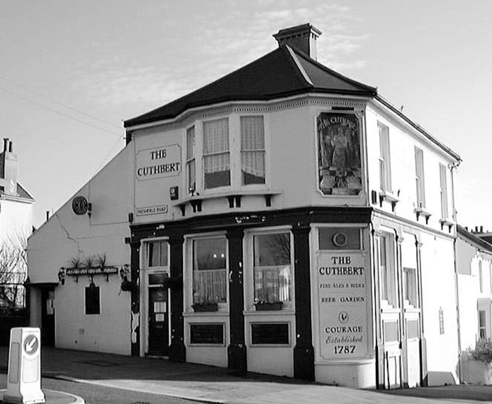 2 2 3 3 1. The Cuthbert; 2,3. The Freshfield Inn. |
Pa1887— 1ESRO DB/D/27/94 2ESRO DB/D/27/72 | |
| Freshfield Street BN2 9 |
Formerly known as Freshfield Terrace. Renumbered 29 January 19011. 1-9 and 11-33 on the north side were designed by F T Cawthorne for William Henry Abbey, whose initial 'A' and the date 1899 are on inscriptions on 11-13 and 31-33; 3-5 and 7-9 look as though they once may have too. Planning application: 1 December 18982. 1 still bears the original tile-and-iron-frame street name. 2-24 on the south side were designed by F T Cawthorne for Hawthorne. Planning application: 21 December 18993. 35-45 were built by George Burstow for Earnshaw; planning application dated 20 December 1900 4. 47-59 were built by George Burstow for Earnshaw; planning application dated 16 October 19025. Apart from two houses built for and by Foord in 19026, Burstow built all the remaining houses for Weeks: two sets of six in 19067, 10 more in 19078 and the final six in 19109.  |
1ESRO DB/D/27/112 2ESRO DB/D/7/4855,4856 3ESRO DB/D/7/5090 4ESRO DB/D/7/5264 5ESRO DB/D/7/5579 6ESRO DB/D/7/5760 7ESRO DB/D/7/63056141,6105 8ESRO DB/D/7/6305 9ESRO DB/D/7/6411 |
|
| ∫ Freshfield Terrace | Incorporated into Freshfield Road by 1882 but renumbered 20 January 19011. | 1ESRO DB/D/27/94 | |
| ∫ Freshfield Terrace | Renamed Freshfield Street [qv] and numbered 29 January 19011. | 1ESRO DB/D/27/112 | |
| Freshfield Way BN2 0 |
On the site of the former Kemptown railway station forecourt. Freshfield Way under construction. |
||
| Friar Close, Surrenden BN1 6 |
Cul-de-sac of detached executive houses built on the Hollingbury Copse estate. | Ke1968— | |
| Friar Crescent, Surrenden BN1 6 |
Built on the Hollingbury Copse estate. Numbered 15 May 19451. | Ke1937— 1ESRO DB/D/27/251 |
|
| Friar Road, Surrenden BN1 6 |
Built on the Hollingbury Copse estate. Numbered 2 May 19391. 7 was the residence of Alderman Miss Margaret Hardy no later than 1947 until he death in 1954. |
Pi1925— 1ESRO DB/D/27/54 |
|
| Friar Walk, Surrenden BN1 6 |
Cul-de-sac of three semi-detached inter-war years' houses and a dormer bungalow. No properties in Ke1938. | Ke1938— | |
| Frimley Close, Woodingdean BN2 6 |
Steeply-sloped cul-de-sac of detached bungalows. Numbered 2 November 19611. | Ke1966— 1ESRO DB/D/27/404 |
|
| Friston Close, East Moulescoomb BN2 4 |
Built in the late 1940s. Most streets in the north of the area are named after Sussex villages. | Ke1949— | |
| Frith Road, Hove BN3 7AJ |
One of five adjacent streets commemorated in Victorian painters. which was built c1905 but already laid out on OS1896. W P (William Powell) Frith RA (1819-1909) was an English painter, the others being Landseer, Leighton, Poynter and Prinsep. | Pi1901— | |
| † Fryern Court Cottages, Portslade | Census1881 | ||
| † Fullers Place, Portslade | Off Station Road. | [1881] | |
| Fulmar Close, Hove BN3 6 |
Cul-de-sac of two-storey houses in groups of three with separate garage block. | Ke1970— | |
| The Furlong | A road created in 2018 as part of the redevelopment of the Preston Barracks site in Lewes Road. | ||
| Furze Hill, Hove BN3 7 |
Furze Croft, the seven-storey apartment block designed by R Toms & Partners in 1936 in the moderne style was developed by Bell Modern Flats. It is on the B&H local list. †Merton House was designed by Decimus Burton and built c1845. It was the family residence of William Holme Bodley MD and briefly included his son the architect G F Bodley. Its name was changed to Beaconsfield in 1889. It was demolished in 1958 together with †Furze Hill Lodge and replaced by ____ Furze Hill Court apartment block. Wavertree House was built in 1892, probably for a German physician, Dr J C Uhthoff, and soon enlarged. It is now a home for the elderly blind with access from Somerhill Road. It is Grade II listed1. †Wick Hall, an imposing mansion, was designed in the 1830s by Decimus Burton for Sir Isaac Lyon Goldsmid. It was offered to Hove Council, which considered possible use as a museum but was demolished in 1935 and replaced by ____ Wick Hall, an extensive block of flats developed by Bell Modern Flats in 1936, comprising 166 flats in four blocks. Properties in 1881: Aylesbury Villa, Chaly, Furze Hill House. Furze Hill is seen in G A Smith's As Seen Through a Telescope (1900), Wick Hall was a location for Shadow of Fear (1963).1  2 2 3 3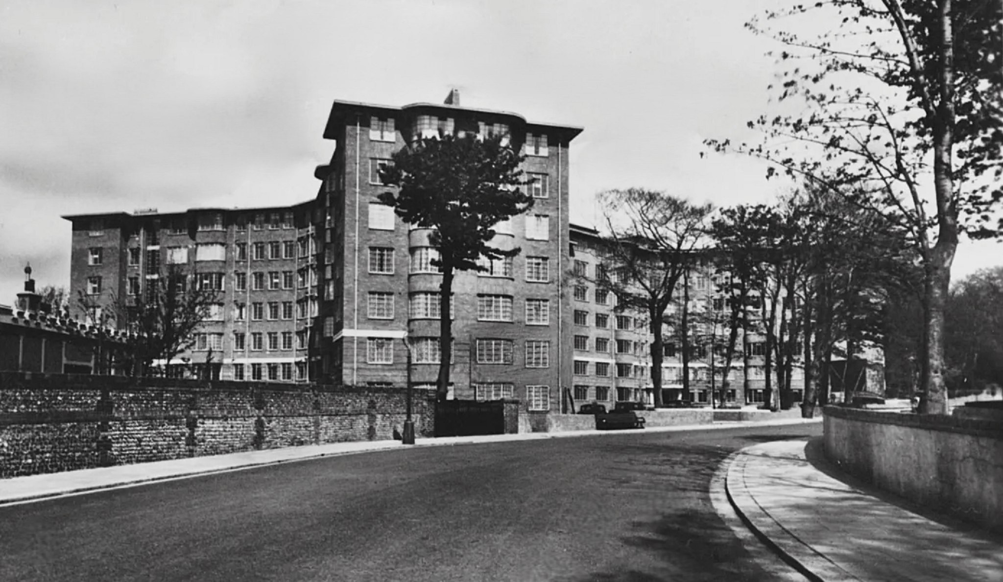 1. Furze Hill entrance to St Ann's Well Gardens; 2. Entrance to St Ann's Well Gardens c1900; 3. Furze Croft apartment block. |
Br1846— 1HE 1398672 |
|
| ∫ Furze Hill Road, Hove | Former name of Windlesham Road. †Windlesham House. 1851 |
Br1846–Pa1881 |
Streets beginning with
A B C D E F G H I J K L M N O P Q R S T U V W X Y Z
Page updated 30 May 2026